Tuesday, March 14, 2017

Python Scripts

  Python is used in GIS to help run analysis tools. Although usually used to create procedures for large data sets, in the section(s) below, python will be used to demonstrate an understanding of some of the more basic uses of python.

Use a Loop to Define, Project, and Extract Rasters.
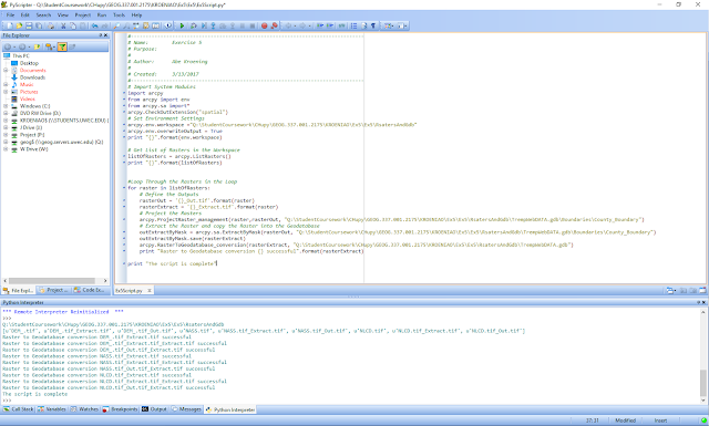
  Figure 2.0 shows a screenshot of the python script which is associated with the post Data Gathering. This python script uses a loop to project the rasters (DEM, Landcover, and NASS), to define the outputs, and to create a copy of the rasters into the Trempealeau county geodatabase. The image will enlarge when clicked upon.

Fig 2.0: Loop to Define, Project, and Extract Rasters


Select Mines
  Figure 2.1 is the python script that was used for the lab Network Analysis of Frac Sand Mines to query out the mines which will use trucks to transport sand from the sand mine to the rail depot. It is assumed that if a sand mine is located within 1.5 km of a depot that a rail spur has already been created and that the map data is out of date. There are three criterion which the query will be based upon:
                                                           1. The mine must be active
                     2. The mine must not have a rail loading station on-site
              3. The mine must not be within 1.5 km of a rail line
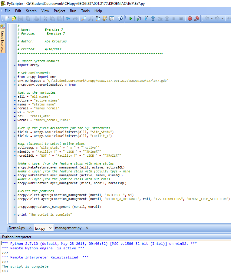
Fig 2.1: Queries, selects, and creates a new layer for the sand mines whose trucks will have an impact on local roads.

Give Weight to a Raster
  This python script shown below in figure 2.2. gives 2x the weight to the Erodable raster while all of the other rasters remain unchanged.  It also adds the input rasters together. This script is associated with the Determining Sand Mine Suitability With Raster Analysis blog. The weighted script was not used as part of the analysis in that lab however. The script's purpose is to demonstrate how a raster could be given a higher weight if it were thought to be more important.

Weighting a Raster
Fig 2.2: Weighting a Raster

Tuesday, February 28, 2017

Introduction to Western Wisconsin Frac Sand Mining


What is Frac Sand Mining?
  Frac sand mining is the process of extracting a very specific sand grain from the ground. The sand has to be well sorted, nicely rounded, and be about half a millimeter in diameter. These quartz sand grains are very strong, as they are used to help prop up rock underground to create pore space during the process of fracking for oil and petroleum. Mining the sand is an intense process. First, the overlying vegetation and unnecessary rock layers must be removed. Second, the sand is excavated and broken up into individual grains. Third, the sand is washed, and sorted. Then the sand is ready to be shipped out. Lastly, the land is ready for reclamation.

Where is Frac Sand Mined in Wisconsin?
  Below (figure 1.0)  is a map which depicts, active, inactive, and reclamation frac sand mine sites in Wisconsin. All of the information, and the map itself was taken from the WI DNR webpage about frac sand mining in Wisconsin which can be found here. The map was edited in Adobe Illustrator so fundamental elements could be created and moved around to make the map look nicer.


Frac Sand Mine Location in Wisconsin
Fig 1.0: Frac Sand Mine Locations in Wisconsin

   Looking at the map above most of the frac sand mines are located in the west central region of Wisconsin.  Specifically, almost all of the sites are located within 100 miles of Eau Claire. There are two main clusters of mine locations. One is located about 50 miles southeast of Eau Claire, and the second one is located just west and northwest of Eau Claire. These following counties have active mine sites as of February 27th, 2017:  Barron, Buffalo, Burnett, Chippewa, Clark, Columbia, Crawford, Dunn, Eau Claire, Green Lake, Jackson, Monroe, Outagamie, Pepin, Pierce,  Rusk, St. Croix,  Trempealeau,  Waupaca, and Wood.

What Issues are Associated With Frac Sand Mining?
  Frac sand mining causes many issues. Most of these issues are environmental related. These issues include but are not limited to:

Groundwater use and Contamination: Frac sand mining can be very water intensive. There is the risk of groundwater wells drying up. Also, flocculants used in the washing process can contaminate local drinking water.

Silica Dust: Consists of very small silica particulates (quartz in this case) which can travel deep into peoples lungs and cause a variety of breathing issues such as silicosis and tuberculosis.

Surface Water Composition: Frac sand mining can change the nonmetallic composition of the river or lake. This can cause changes to siltation, erosion, and fish habitat. 

Land-cover Removal: Frac sand mining requires the removal of all vegetation on the surface. This directs forest health, animal habitat, and drainage patterns.

Traffic: There is a significant increase in traffic. Many large vehicles travel the roads which can be a nuisance to local residents, and can harm roadway.
How can GIS be Used to Explore Some of These Issues?
  GIS is a good way to explore these issues to see how directly related they are to frac sand mining. For example, GIS could be used to map out traffic patterns of sand transporting trucks to see when and where they travel. Also, GIS could be used to monitor stream composition changes which could be used to identify areas of fish habitat loss. It could be similarly used for land cover changes and animal habitat loss. Lastly, GIS could be used to locate areas where people would have a high risk of inhaling silica dust. In future posts, data will be used to help map out the issues associated with frac sand mining, Some of these ideas suggested above may be used, and some may not.

Sources
US Department of Labor, OSHA Fact Sheet, 2002
WI DNR, Industrial Sand Mining Overview, 2016
Wisconsin Geological & Natural History Survey, Frac sand: How is it mined?, 2013 
WI DNR, Locations of Industrial sand mines and processing plants, 2016
WI DNR, Silica San Mining in Wisconsin, 2012
MN Department of Health, Silica Sand Mining and the Evnironment
Wisconsin Public Radio, Is Frac Sand Mining Causing Metal Contamination in Groundwater?